


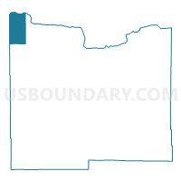
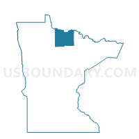
Williams Precinct, Koochiching County, Minnesota
About
Outline

Summary
| Unique Area Identifier | 602825 |
| Name | Williams Precinct |
| County | Koochiching County |
| State | Minnesota |
| Area (square miles) | 68.98 |
| Land Area (square miles) | 68.42 |
| Water Area (square miles) | 0.56 |
| % of Land Area | 99.19 |
| % of Water Area | 0.81 |
| Latitude of the Internal Point | 48.62580810 |
| Longtitude of the Internal Point | -94.35909290 |
Maps

Graphs
Select a template below for downloading or customizing gragh for Williams Precinct, Koochiching County, Minnesota


Neighbors
Neighoring Voting District (by Name) Neighboring Voting District on the Map
- 2-A Gudrid Unorg. Voting District, Lake of the Woods County, MN
- 2-C Unorg. Voting District, Lake of the Woods County, MN
- Murphy Precinct, Koochiching County, MN
- West Koochiching Voting District, Koochiching County, MN
Top 10 Neighboring County Subdivision (by Population) Neighboring County Subdivision on the Map
- Northwest Koochiching UT, Koochiching County, MN (463)
- Gudrid township, Lake of the Woods County, MN (219)
- Township 158-30, Lake of the Woods County, MN (36)
- Rapid River township, Lake of the Woods County, MN (12)
Top 10 Neighboring Unified School District (by Population) Neighboring Unified School District on the Map
Top 10 Neighboring State Legislative District Lower Chamber (by Population) Neighboring State Legislative District Lower Chamber on the Map
Top 10 Neighboring State Legislative District Upper Chamber (by Population) Neighboring State Legislative District Upper Chamber on the Map
Top 10 Neighboring 111th Congressional District (by Population) Neighboring 111th Congressional District on the Map
Top 10 Neighboring Census Tract (by Population) Neighboring Census Tract on the Map
- Census Tract 7905, Koochiching County, MN (2,419)
- Census Tract 4603, Lake of the Woods County, MN (1,694)